
Maps and Plans

Date: 1830
Source: plan of the city of Norwich surveyed by Millard and Manning
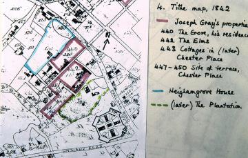
Date: 1842
Source: ‘The Plantation Garden’ by Sheila Adam, UEA dissertation 1996

Date: 1873
Source: as PGPT341
Unfortunately, the map’s accuracy cannot be relied upon e.g. there are too many houses shown in Chester Place; so that the features shown in the Plantation garden may or not be accurate. It seems unlikely that there were trees rather than a lawn in the centre.

Date: 1883 with later additions
Source: ‘The Plantation Garden’ by Sheila Adam, UEA dissertation, 1996

Date 1897
Source This map was used in the auction particulars when Henry Trevor’s estate was sold in 1897. It was based on the O.S. map of 1883/4

Date 1897
Source See PGPT054

Date:1924
Source: Sale Particulars of the sale of Heigham Grove House in 1924
This plan shows a very similar arrangement to the 1883 O.S. map. In 1854 Chas Winter, boot and shoe manufacturer, was the owner. Horticultural shows were held in his grounds. The estate was sold in 1924 for £2725. In 1925 the City Council bought it for £3200 and converted it into the City Maternity Home.

Date 1883/4
Source O.S. map

Date: 1908 with annotations of 1919,1934 and 1950
Source: Plan in PGPT archive
The water supply for the whole premises is shown, including the supply from the mains to the fountain and various taps, the furthest being at the South end, at the top of the Italian terrace.
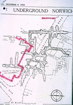
Date: December 9, 1939
Source: Eastern Daily Press
No one can be sure of the original date or purpose of the tunnels. ‘John Bond 1571’ was found carved into the wall and gives us a clue. Mining for flints has been one suggestion, digging out chalk another. We have always assumed that the quarry in which the Plantation garden was created was formed by excavating for flints and chalk.

Date 1990s
Source Plan prepared to illustrate guided walks.
That map was used by the auctioneers, Spelmans, when they advertised the sale of Henry Trevor’s properties in 1897. On their map the names of the owners of the adjacent properties on the Earlham and Unthank roads were shown. In turn that map was copied and numbers added in the 20c to identify various features for visitors, and dotted lines drawn to indicate the variety of circular walks which Henry Trevor had designed to add interest to his garden.

Date: 1990s
Source: Publicity leaflet
This map was based, by permission, on Geographers’ A-Z and O.S.

Date: 1995
Source: Diagrams for volunteer guides


Date: 1960s
Source: O.S. map with later additions
The outlines of earlier gardens (see PGPT291) make it clear how many houses were built in the 20c on the former large gardens of the 19c.

Date: August 2007
Source: Photograph by volunteer
Henry Trevor’s aim was that there should be attractive views down on to the bedding from the upper walks he created around the sloping sides ( see PGPT098 for plan with walks marked).
![]()